


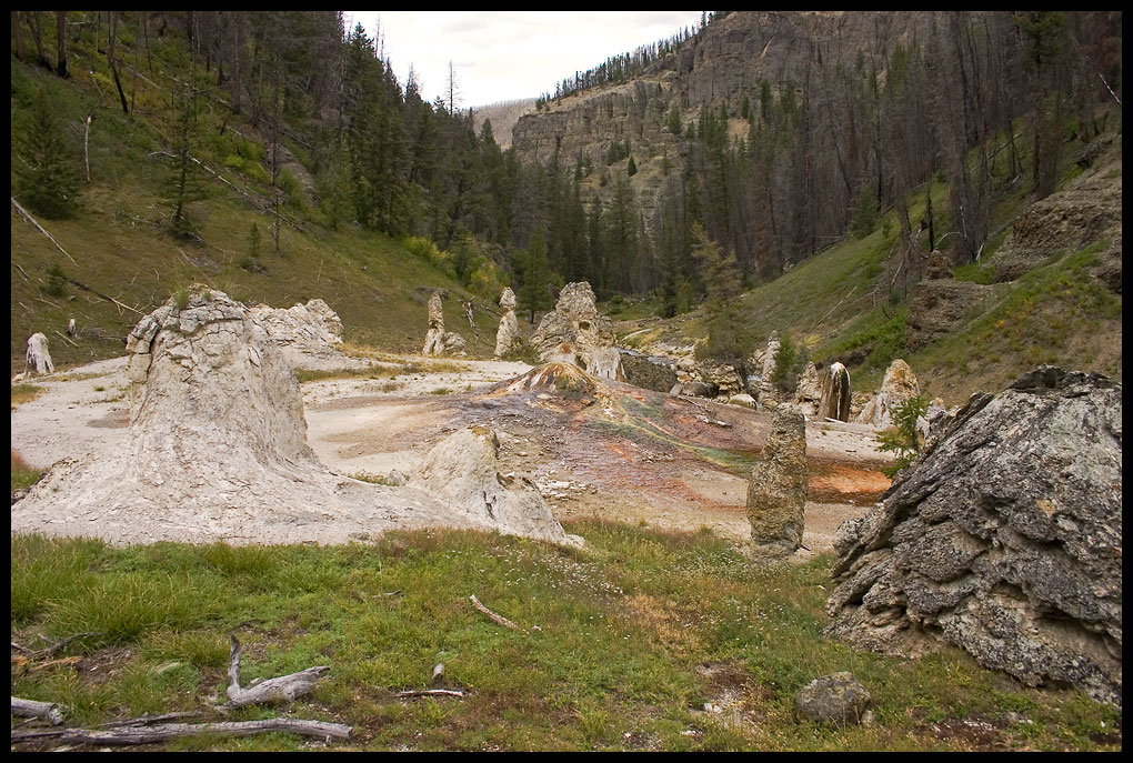
Fairyland is a thermal basin of large, mostly dormant travertine cones. Before I read Rick Hutchinson's reports on the area I didn't know that such formations in such quantities are rare anywhere, let alone in Yellowstone. Even with the recent damage to some cones along Shallow Creek, there are well over fifty cones of various sizes. Some are small and stumpy-only one or two feet tall. Others are well over fifteen feet high. Several of the cones which line the perimeter of the Shield are eight to ten feet tall. Most of the tall, narrow cones line the banks of Shallow Creek. Collectively they are known as the Gnome Group. The thermals that line Broad Creek seem to want to grow in a more haphazard kind of way. They tend not to be narrow cones, but broad formations with tentacle-like spires that reach to the sky. In this respect they are more like some of the formations at Monument Geyser Basin. There are several super-heated springs near the banks of Broad Creek. One is creek-side where we like to pump water. There is another up the hill from that one, also with an overflow into Broad Creek.
The interior of the Shield seems to favor cones more like the Pitcher's Mound and the Center Cone. These features tend to be shaped like the classic volcanoes in the Cascade Range, although there are some smaller conical shaped features that are not near one of the creeks.
The Pitcher's Mound seems much more active and colorful than it was in 2005. There seems to be at least two vents with bubbling water and the water is hot enough to produce some steam. I did not have a thermal gun with me, but it does not appear to be superheated. The runoff from the spring produces a variety of colors. In 2005 the colors produced by the algae were mostly brown. Now we see not only the browns-a near-dark chocolate brown and a more milk chocolate brown--but bright greens and oranges. There are some hot areas of white near the top of the cone. Some of the runoff is a deep, deep maroon, almost purple and some of the runoff makes it into Shallow Creek. From other areas the runoff produces a mere wet area on the broken travertine of the Shield.


When we visited Fairyland in 2005 I was sure that there had been further erosion on the Cutaway. This time I am also convinced that more of the bottom portion of that cone is missing. I mention this to Lori and she says, "I see what you mean." But when I get home and look at the photos I am less inclined to think that. The Cutaway is very interesting because the missing portion of the cone exposes the plumbing system. A narrow travertine tube extends from the ground up into the cone. Do all the cones work in this way or is this one unique? There is no way of knowing, but recent damage in Fairyland does allow views into other plumbing systems. There is a hint or two in Rick Hutchinson's report that seem to indicate that the Cutaway was in much the same condition in 1976.
But how did the Cutaway get this way? I don't think anyone can know for sure. It may be that part of the cone shifted towards Shallow Creek, thus weakening the base of the cone. Something may have struck the base of cone, shattering it and exposing the plumbing. Whatever the case, the Cutaway has shown a remarkable staying power in spite of its damaged condition.


When I first visited Fairyland in 2003 the Magic Mushroom was by far the most active feature of the basin. At the top of the cone, near the vent, was a prominent area of white. By 2005 that area had shrank considerably while at the same time the Pitcher's Mound and a few other cones on the Shield had reactivated. I knew from photos I had seen in a 2006 trip report that the Magic Mushroom was now dormant. So that was not a surprise. Broad Creek has shifted and now flows over much of the base of the Mushroom. Did the shift in water levels drown the Mushroom or was there an exchange of function away from the Magic Mushroom and towards the Shield and the Pitcher's Mound? If there was an exchange of function, would that indicate that the heat source for Fairyland is reasonably constant? And if that is true, is it reasonable to think that Fairyland has never been more active than it is now? That is, should one think that there have only been a few cones active at any one time rather than many features active in a more interesting and colorful past?
What may have caused the changes in Fairyland? What we know is that there is evidence of erosion along the banks of Shallow Creek. This erosion extends from Fairyland upstream at least a quarter of a mile and maybe as far as half a mile. Rocks have been thrown into the creek and possibly moved far down stream where they have been seemingly caught by the boulders that lie below the Shield at the former confluence of Broad Creek and Shallow Creek. In addition, one giant cone-it stood close to some 15 feet tall in 2003-has been thrown into Shallow Creek and the course of the creek is now changed to flow through the area vacated by the cone. There are rocks, trees and other debris strewn along the banks of Shallow Creek. Was there a sudden discharge of water during the spring melt that caused this? Perhaps an earthquake loosened the banks of the creek and caused a cascading chain of events?


There is a tantalizing clue in Shallow Creek. In addition to the damage to the cone that has been thrown into the creek, there is a portion of the base of the cone that stood next to the fallen cone that is missing-the cone called "the Tree Hugger" by Paul Rubinstein. Not far from that cone there is a boulder in Shallow Creek that, as far as I have been able to determine from my 2003 photos, was not there in 2003. The boulder is of the type of rock that one finds in other boulders in Shallow Creek and is the type of lava that is typical of the cliffs above Fairyland to the east. Did a boulder roll down the hill, smash the 15 foot cone knocking it into Shallow Creek and then removing the base of the Tree Hugger? Could all of the damage have occurred due to a related event?
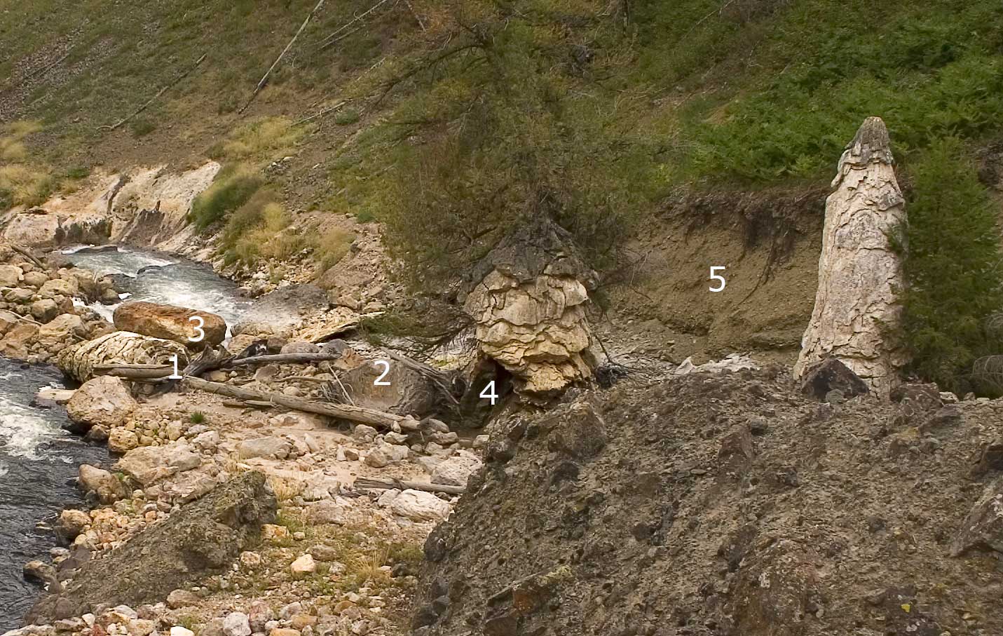
I have numbered a few items in this photo to show some of the changes in Fairyland since 2003.
When did these changes in Fairyland take place? My trip in 2003 was in late August and I returned again in June, 2005. So sometime in those 15 months or so something happened. I have not been able to find any trip reports from Fairyland during the summer of 2004. When I look at the changes and the slides along the creek and the giant boulders that have fallen from the cliffs above Fairyland I cannot help but think that there are some pretty frightening days to be in Fairyland.


It's not all gloom and doom, of course. There is an elk antler in the basin and Lori and Laurie want a photo with the antler.


"We have to have a picture," says Lori. "It's a tradition." I gladly comply with the request.


It is interesting to see how the cones seep from fissures in their sides rather than solely from a vent at the top. There are some cones that have another cone within them. I wonder if they got started from a seep that continued to grow, thus undermining the top of the cone? If there is a lesson to be learned from Mammoth hot springs it is that travertine features like to shift around.
Then there is the case of "The Dancer." This diminutive cone on the southern side of the Shield stands some five feet tall. But it does not appear to be made simply from travertine. Were other rocks and minerals dissolved in the spring which made the Dancer? Some of the coloration is similar to rocks found on the lava flows above Fairyland or even in the newly exposed rocks in the creeks.


Laurie announces that the water filter no longer works. I take it down to Broad Creek to clean it and to finish filling the water bottles. So I pump a bottle or two, then clean the filter, and then start on another set of bottles. Just as I am finishing up the last bottle and cleaning the filter for the last time, two dippers came racing up Broad Creek, one chasing the other. They skillfully dart through the boulders. I have never seen a display of wildlife quite like this in Fairyland. They disappear behind the largest of the boulders in the creek.
"Did you see that?" I call to the others. I am thrilled that everyone saw the dippers. It was a scene more out of one of the creeks in the Columbia River Gorge than a scene out of Fairyland. For the first time we have actually seen wildlife in Fairyland.
I ask Laurie to take a short video of Fairyland while I work on repairing my blistered feet. Then I take my turn at taking a video. It is just about my last task before leaving Fairyland. Finally I grab my camera and hurry up the hill along Broad Creek. I want a few shots looking down at the basin. I don't get as high up as I would like, but it is interesting because I have never been back in this area.
My Fairyland Video. A few mistakes while I was talking. First, there is only one fallen cone, so scratch the "there and there". "The Sentinels" were so named by another party, not by Paul Rubinstein's party.
Laurie's Fairyland Video. A few notes. There have probably never been geysers in Fairyland. Substitute "thermal" when she says "geyser". When she says "hot pot" she simply means "thermal", not a "hot pot" in which you could soak.