MacMurchy
Tombstones Located in Canada
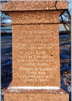 
This is a picture of Thomas McMurchy and
Mary Blue's tombstone (at left) located in the Old Stone Church, Strange, King Township,
York County, Ontario, Canada. The stone reads as follows:
Thomas McMurchy, died 8th May 1849, Aged 91
years. A Native of the Parish Killan, Argyleshire, Scotland. - Mary Blue, Wife of the
above, died 23rd July 1854, Aged 81 years. - Thomas McMurchy, Their son, died 25th Dec
1876, Aged 68 years.
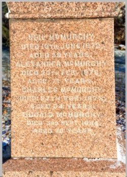
The reverse side of the stone (at right)
reads:
Neil McMurchy, died 10th June 1872, Aged 59
years - Alexander McMurchy, died 20th Feb 1878, Aged 76 years - Charles McMurchy, died
27th Feb 1878, Aged 64 years - Dugald McMurchy, died 3rd Sep 1886, Aged 70 years.
After Thomas's father's death in 1822,
Thomas took over the tenancy in Lenagboyach, as well as the one in Lagloskin which was
used for sheep raising. Here in Lenagboyach, Thomas lived with his brother, and this is
where they both raised their families. Sometime shortly after 1822, Thomas moved his
family to the farm at Stewartfield in Kilcalmonell Parish. Thomas was recorded as the
ruling elder inthe Clachan Church in Kilcalmonell Parish, Kintyre in 1825. In 1839, Thomas
and family were evicted form Stewartfield. This prompted Thomas and family to emigrate to
Canada the next summer of 1840. |
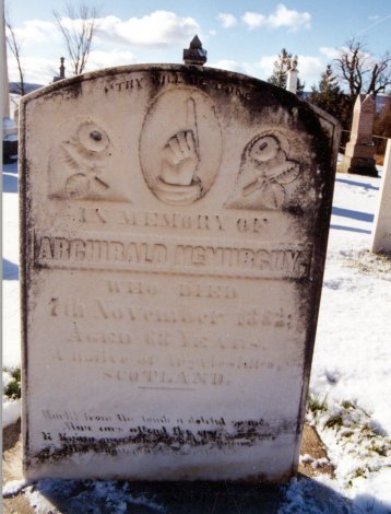 This is a picture of Archibald McMurchy's (1797-1862) tombstone located in
the Presbyterian West Church Cemetery, Nottawasaga, Ontario, Canada. The tombstone reads: This is a picture of Archibald McMurchy's (1797-1862) tombstone located in
the Presbyterian West Church Cemetery, Nottawasaga, Ontario, Canada. The tombstone reads: In memory of Archibald McMurchy, who died 7th
November 1862, Aged 68 years, A native of Argyleshire, Scotland.
Archibald is named in Angus Martin's
"Kintyre Country Life", as an inebriated perpetrator in a 1818 New Year's day
shinty match, in which Archibald badly injured an opponent as a result of a verbal
disagreement. His brother Donald is also mentioned. Archibald married later that same
year. Sometime before 1834, Archibald, his family, and brother Donald emigrated to King
Township, York County, Canada West (Ontario).
Around 1834, Archibald moved to Nottawasaga
Township in Simcoe County where he settled on 400 acres, lot 39, concession 12, just east
of the base of the Blue Mountain escarpment, which became known as McMurchy Settlement. Of
this property, 200 acres was on what is now the Nottawasaga Township line, and 200 acres
on what is now the Nottawa Sideroad. His brother Malcolm also moved up from King Township
later, and settled across the road on 200 acres, lot 9 of Collingwood Township. This name
can still be found on extant maps of the area. At one time, the Settlement had its own
school, called MacMurchy's school, built of logs on a corner of Malcolm's farm in 1855.
Many other Scottish settlers followed and built in the same area.
The first Settlement church services, both
the Free Church of Scotland and the Auld Kirk, were held in the home of Archibald with
Gaelic the language of the services. One night eleven children were christened. In 1853,
West Church was built several miles away, and the MacMurchy's joined this congregation of
which Archibald was an original trustee. They built the first brick house in the area in
1860. Archibald's son, John, took over the farm after his father's death until his own
death in 1880. Then his brother Thomas, operated the farm until 1892. |
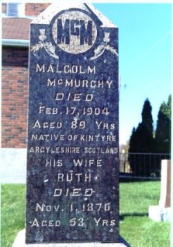 This is a picture of Malcolm McMurchy's (1797-1862) tombstone located in
the Presbyterian West Church Cemetery, Nottawasaga, Ontario, Canada. The tombstone reads: This is a picture of Malcolm McMurchy's (1797-1862) tombstone located in
the Presbyterian West Church Cemetery, Nottawasaga, Ontario, Canada. The tombstone reads: Malcolm McMurhcy, died Feb 17 1904, Aged 89 yrs.,
Native of Kintyre Argyleshire Scotland - His wife Ruth, died Nov 1 1876, Aged 53 years.
Malcolm and his bride-to-be left King
Township, and on their way to MacMurchy Settlement in Collingwood Township, they married
in 1845 in Bond Head. Malcolm was joining his oldest brother, Archibald, at MacMurchy
settlement. He established his farm across the township line from his brother on 200 acre
at lot 9, concession 1 in Collingwood Township. In 1855, Malcolm was appointed by the
Township council to the position of fence viewer, who role was to check on fences along
roads and settle any fencing disputes among land owners. That year, Malcolm was also a
pound keeper for his area who were deal with stray cattle, horses, pigs and sheep. In
1851, the census taker noted "At number nine,Concession 1, there was some show of
comfort, a shingle-roofed dwelling and a thrifty appearance about the premises. That and a
few other buildings were all that I yet saw deserving the name of houses; the others, many
of them were covered with bark or split logs". There were about 30 acres cleared at
that time. This property now is the location of a ski hill called Osler Bluffs. Later,
Malcolm added 200 acres further north on lot 12. On this property had been an Iroquoian
village, and a fluted stone point was found that dated 10,500 years old. After his wife's
untimely death, Malcolm remarried and fathered more children. A son of this marriage,
Murdoch, farmed one half of the lot 12 after his father's death. The first schoolhouse was
built on the corner of Malcolm's farm in 1855 and was known as MacMurchy's school. |
 . .
Best viewed at
1024x768 with MS Explorer 5.5 or higher,
Copyright 1994-2001, Carmichael Family OnLine
Comments & questions about web page to Matthew
Carmichael |