GEOG 5121 Project 1:
Coordinates and Projections
By:
Tom Wells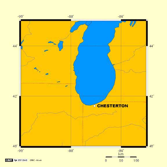
CHESTERTON, INDIANA
You may have already recognized where we live in North West Indiana by the nearby great Lake Michigan. This is a relatively large scale map (in the geographic sense) compared to the example report because it only covers 5 degrees of latitude and longitude instead of the entire world. (From 90° to 85° West and 40° to 45° North.)
The map was prepared via the Online Map Creation site, using the Equidistant Cylindrical map projection. Therefore there is some size & shape distortion but it is not noticeable over such a relatively small area. The advantages of Equidistant Cylindrical map projection is the equivalency of distances and angle measurements.
Adobe PhotoShop 6.0 was used to improve both the labeling of our town's name and the image's color fill.
The place name, Chesterton, shown on the map above, represents the location of my home town. The geographic coordinates of Chesterton are:
Latitude: 41° 36' 38" N, Longitude: 87° 3' 51" W
Latitudinal and Longitudinal coordinates are based on a global (spherical) coordinate system that divides the earth into 360 degrees both North-South and East-West starting at the Equator and the Prime Meridian (as 0,0). The Prime Meridian was established through the Observatory at Greenwich, England in October of 1884 when 25 nations met in Washington, DC (USA).
The UTM coordinates (NAD83) of my home town are:
Easting: 494653.590 meters, Northing: 4606540.113 meters, Zone: 16 (North)
UTM coordinates are based on 60 zones surrounding the earth with the exception of the polar regions. By dividing the earth into 60 "Transverse Mercator" map projection, coordinate error is limited to no more than 1 part per 2,500. Note: NAD83 refers to the North American Datum of 1983. The origin is the earth's center of mass. Another popular horizontal datum is NAD27; the North American Datum of 1927. The origin of this datum is a point on the Earth in Kansas known as the Meades Ranch. The more uniformly accurate NAD83 standard has replaced NAD27 but old USGS topographical maps reference the older standard.
The State Plane coordinates (NAD83) or other local coordinates of my home town are:
Easting: 901597.565 meters, Northing: 706364.300 meters Western Zone (NAD83 Zone: 1302)
The state of Indiana has a primarily North - South orientation in that the state is taller (north - south) than it is wide (east - west). Indiana is large enough to justify two state coordinate zones. (Alaska has 10 zones). Because of the state's "vertical" orientation, Indiana is divided into Eastern and Western State Plane Coordinate zones based on Transverse Mercator projections. Both zones are within UTM zone 16. Chesterton Indiana is about in the middle of the Western Zone with respect to the Illinois state line and the start of the state's Eastern Zone between La Porte and St Joseph counties.
Coordinate Systems Compared
Chesterton,
Indiana has been located on the earth's surface using three coordinate
systems; Geographic, UTM and Western Indiana State Plane (Regional).
Of the three, only the Geographic Coordinate system covers the entire
earth's surface. It can do so because it is a spherical coordinate
system encompassing the entire globe. However geographic coordinates
are difficult to work with when calculating distances or directions.
Therefore portions of the globe are converted to plane coordinate systems
to produce two dimensional maps. The UTM coordinate system covers
most of the globe (except for the polar regions) using 60 zones to limit projection error. The continental United States is covered
by 10 UTM zones; from California in zone 10 to Maine in zone 19.
The Indiana Western Zone state coordinate system is similar to the UTM
coordinate system because they are both plane coordinate system and they
are both based on Transverse Mercator projections. However, the Indiana State Coordinate Zones cover a much smaller area than a UTM
zone so the maximum projection error is less. Both the Eastern and Western Zones fall within UTM zone
16.