GEOG 5222 Project 1 |
Decision Support with a GIS |
by Tom Wells - July 2003 |
|
The first data cut can be made with the County layer based on the following attribute criteria:
Only 11 counties out of the 43 meet the above criteria. Just about any data query tool could process this simple single table, three criteria query. However, a GIS is required to determine which of the 48 cities fall within the 11 counties (because the county boundaries are irregular polygons). ArcView 8.3 was installed for this class, a state-of-the-art GIS with both attribute and geospatial based data selection capabilities. Note: 17 of the 48 cities fall within the 11 counties (as saved as layer CitiesQuery1). The second data cut can be made with the city attribute data table:
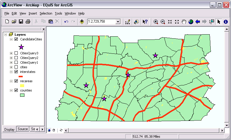
Just 9 of the 17 remaining cities meet these two criteria (CitiesQuery2). Criteria A.3 also requires a GIS spatial query. Just 7 of the 9 remaining cities are within 20 miles of an interstate (CitiesQuery3). Note: this is NOT the same as being within 20 miles of an interstate interchange. Toll roads (like the Pennsylvania Turnpike) often have a very limited number of access points. The remaining criteria, B.2; "at least one recreation area with 10 miles", is a spatial query. Only 4 of cities make the final cut (CandidateCities) as shown in figure 1 via the large stars. | |
|
| |
| Figure 1: |
Project 1 required deliverable showing 4 cities that meet the specified criteria. Note: The relatively straight southern boundary of the mapped area is approximately 220 miles long. |
|
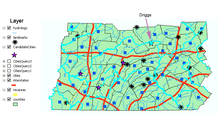
Figure 1 does not include any data selection subsets in that selected data is saved as new layers and layers are either totally on or off. Conversely, the following figure shows two data subsets within two layers; Hydrology and CandidateCities. The hydrology data set is restricted to rivers and lakes as shown by the bright turquoise highlighting that thickens the hydrology features. (The un-highlighted hydrology features are mostly "streams".) All of the 48 cities in all 43 counties are also shown in Figure 2. Most of the cities are indicated by dark blue squares. Based on the two additional criteria, only one city of the four CandidateCities meets all of the selection criteria. |
|
|
|
| Figure 2: | The two optional criteria reduce the number of candidate cities to only only one; "Driggs" as shown selected here. |
| The selection, a single city, also shows in the "CandidateCities" attribute table via turquoise highlighting. | |
|
|
|
|
Figure 3: |
Only one of the four Candidate Cities meet the extra Hydrology and Landmark criteria. |
Sources | |
|
|


