GEOG 5222 Project 2 | |
Summarizing and Displaying Property Damage from Tornadoes | |
| Properties Damage |
Tornado property damage data from multiple super-cell thunderstorms
in central Oklahoma on May 3rd, 1999 was provided. Approximately 42 people died
and 795 were injured in a matter of hours (in the late afternoon and
evening).
This project summarizes and presents the data in a graphical form using thematic maps generated with ArcView 8.3. This is the first project involving data manipulations. It was very interesting to see ArcView's data handling capabilities in action and especially the well integrated VBA script usage in calculated fields. The project was presented in three parts:
Step 2 included most of the work. In this case, two database files (countydamage.dbf & countystatistics.dbf) were joined to a projected Counties shape file data set and used to create a new shape file with 17 selected records; TornadoCounties (one for each county with some damage). Likewise, a database file (TornadoAttribs.dbf) was joined to a projected TornadoPaths shape file date set and used create a new shape file; Path_Attribs (with all 56 records, one for each path). Calculated summary fields were added to the TornadoCounties shape file database and used for thematic mapping. The variable specified in each layer is include in the legend. (The last four of the fields each have their own figure.)
Only one field was added to the Path_Attribs shape file database to convert a text field to a numeric field (ArcView color ramping requires a numeric variable). Fscale_num stands for the Fujita scale where 0 is the weakest and 5 the strongest tornado.
|
|
Each of the figures include the Tornado Path layer with the paths colored according to their Fujita scale. The mapped area in central Oklahoma state is 205 miles wide. Only the 17 counties impacted by the May 3rd, 1999 event are mapped. The other counties in central Oklahoma state are included for spatial reference. | |
|
| |
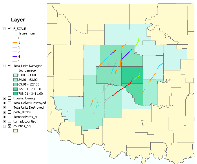
| Figure 1: |
Property Damaged - Houses, Apartments and Mobile home units damaged May 3rd, 1999 in central Oklahoma state. |
|
|
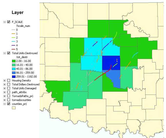
| Figure 2: | Properties Destroyed - Houses, Apartments and Mobile home units destroyed May 3rd, 1999 in central Oklahoma state. |
|
|
|
|
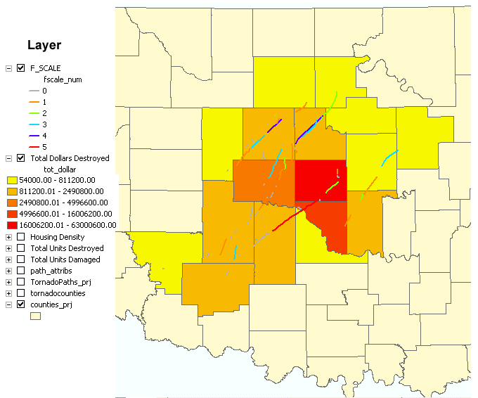
Figure 3: |
Property Destruction in Dollars - The value of the destroyed property presented in Figure 2 is estimated based on the supplied median property value times the total number of units destroyed. |
|
|
|
|
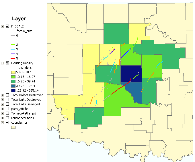
Figure 4: |
Housing Density in Units per square mile per county - Calculated value based on total number of houses, apartments and mobile home units in each impacted county divided by the area of the county. |
|
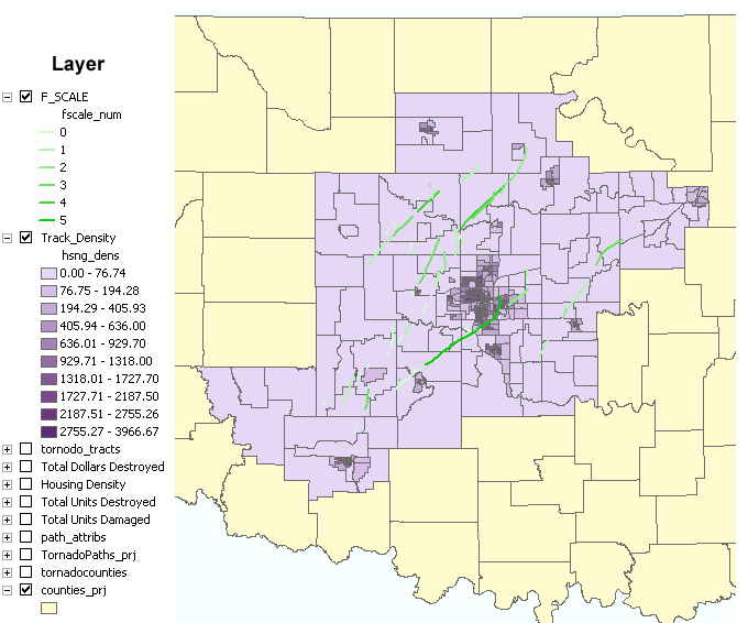
Optional Additional data from the federal US 2000 census was downloaded (from psu.edu) and utilized to create a more detailed version of Figure 4 based on census tracks instead of state counties (even the most sparsely populated county of interest, Kiowa, has three tracks). The provided shape file (tornado_tracts) was already defined as "GCS_North_American_1983" and projected as "NAD 1983 StatePlane Oklahoma North FIPS 3501 Feet" to match the project specifications. Data manipulations included joining the demographic data to the census tracts layer plus adding and calculating a housing density based on the provided data fields. (I did check that the area field content was provided in units of square mile.) The thematic map presented in Figure 5 includes 10 categories instead of the default value of 5 like the other figures. The tornado paths are shown in shades of green for contrast. |
|
|
|
|
|
Figure 5: |
Housing Density in Units per square mile per census track - Calculated value from US 2000 census data. |
|
As one would expect, the most damage and housing unit destruction occurred in the county where the population was the highest since it was also hit by the strongest storm. "Only" one Tornado was rated F-5, the most destructive rating, on the Fujita scale. Figure 5 above shows the F-5 Tornado path crossing some census tracks in Oklahoma City. | |
|
Sources | |
|
|
|
Appendix - Calculation Checking | |
|
Checking calculated fields with a calculator is a straight forward but tedious approach. I found that ArcMap 8.3 can export a table table as a database file which can be read by MS Excel 2000. Therefore, I used Excel to verify my calculated fields and saved the file as an xls file to preserve the equations. The Excel based file is available for download. Go To the Top of Page | |