GEOG 5222 Project 4 | |
Geocoding Addresses of Customers Who Performed Home Radon Tests | |
by Tom Wells - July 2003 | |
| Address Locations |
ArcView supports "Geocoding Services" that can be used to map a
point location based on only a street address. This project maps the
addresses of imaginary home radon tests over a thematic map of "Radon
Potential".
Project 4 was described in four parts.
Geocoding, both batch and interactive mode, are introduced in lesson 4. Step 2 demonstrates problems with bad data and how to manually compensate. Radon Potential analysis includes an interesting geoprocessing union operation. Step 4 shows how to locate a single address on a thematic map. |
|
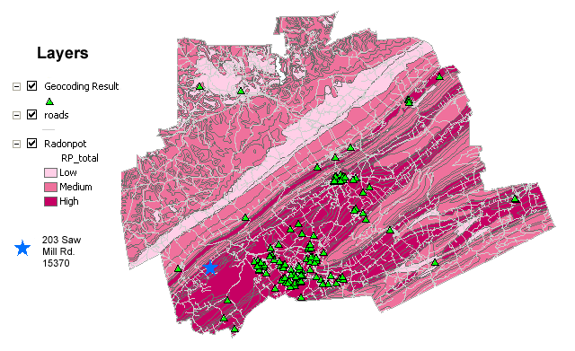
The radon potential thematic layer was created by performing a union (mathematical, not labor) on two supplied shape files representing soil and rock. Both attribute tables contain potential radon ratings on a scale of 1 to 4. The union geoprocessing combined the 42 soil polygons with the 343 geology/rock polygons to create 823 soil & rock combination polygons (due to the intersections of differing polygonal shapes). The soil and rock potential radon ratings were simply added together and then normalized to represent low, medium and high radon potential regions. | |
| Figure 1: | Radon Potential, Roads and Geocoded Street Addresses map. An individually located address (at 203 Saw Mill Road) was located and turned into a blue star on the map to report that it is in a relatively high potential radon risk area. The 15370 zip code belongs to Greene county, Pennsylvania but the map apparently comes from elsewhere because this is a fictional data set. (The geology looks like central Pennsylvania.) The map represents approximately 40 miles horizontally. |
|
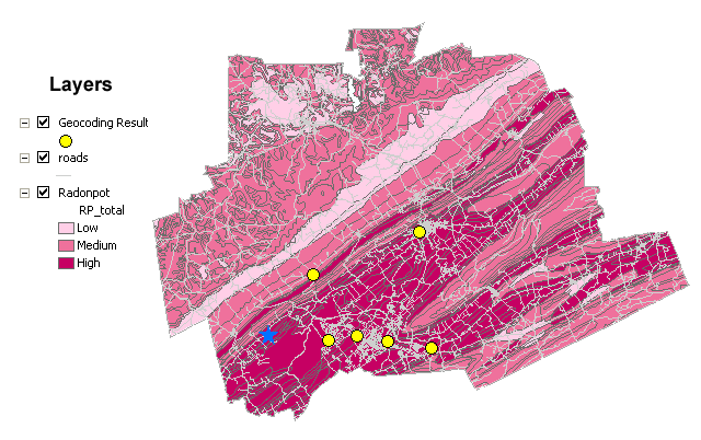
An additional 6 records were downloaded in a single table/address for geocoding. One address would not match until the zip code was corrected. The street was valid but in the wrong zip code. | |
| Figure 2: | Radon Potential, Roads and additional (optional) Geocoded Street Addresses map. The map represents approximately 40 miles horizontally. |
|
I imagine that rock and soil risk factor addition is a very crude approach to radon potential. The most famous case was due to a house built on rock:
Rock and soil (sometimes called unconsolidated rock by
geologists) are closely related so I imagine that they can both produce radon
gas but the interaction of soil on bedrock is not a mater of simple
addition. For example, a thick deposit of virtually impermeable clay would
tend to seal even the most radioactive rock.
| |
|
Sources | |
|
|
|
Appendix | |
|
In this project the geocoding service was provided. Therefore we did not need to pick the correct style that could work with our data set.. ArcView 8.3 comes with several predefined geocoding service styles designed to work with common address data formats.
According to the ArcMap "Geocoding Services Manager", the provided service (roads.mxs) is in the "US Streets with Zone (ArcView Style)" geocoding service style. Right clicking on roads.mdx in ArcCatalog and selecting properties lets the operator see the "Geocoding Service Properties" form. This dialog form includes a "Fields" section that shows how the reference data (roads.shp) is mapped for this geocoding service. The following mappings are included. Data examples or type (address numbers are integer fields) are listed as well. | |
| Geocoding Fields |
Roads.shp |
(data examples or type) |
| PreDIr | FDPRE | (W, E, N, S or null) |
| StreetName | FNAME | (State Hwy 504, etc.) |
| StreetType | FTYPE | (Way, St, Rd, etc.) |
| SufDir | FDSUF | (W, E, N or null) |
| LeftFrom | LEFTADD1 | (address number) |
| LeftTo | LEFTADD2 | (address number) |
| RightFrom | RGTADD1 | (address number) |
| RightTo | RGTADD2 | (address number) |
| LeftZone | ZIPL | (5-digit zipcode) |
| RightZone | ZIPR | (5-digit zipcode) |
|
The first four field names are actually mapped three times each to different Geocoding Fields with similar names. Apparently the service can support two aliases for each of these character fields. |
Go To the Top of Page

