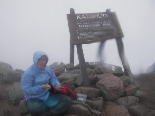
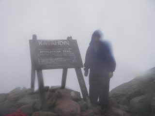
Maine - Mount Katahdin - 5,267 Feet - August 29, 2004
Thursday, July 5, 2007 - We got up at 4:30, left the campground at 5 and arrived at Baxter State Park at 5:45. The gate was open.
we paid the entrance fee and were warned that this was a level 2 weather day. That meant that the rangers did not recommend climbing
above tree line. There was no one else in the parking lot for the Katahdin Stream (Appalachian) Trail. I found another ranger at the
Katahdin Stream Campground. He said the decision to hike was one each hiker had to make. It was raining. One thing he repeated was to take
short breaks and keep moving to stay warm. We hit the trail around 6:30. This is a tough hike. It is 10 miles round trip with 4000 feet
of elevation gain. Miles 2 to 4 are scrambling over large boulders. It was foggy and we could not judge our progress. When we reached a
rock with "2M" on it, I could not believe we still had 2 miles to go. The last mile levels out, except for the last fourth. We reached the
top around noon. There is a large pile of rocks that people add to, trying to make the peak a mile high. The return took about 4 hours.
 |
|
Friday, July 6, 2007 - We drove toward home, as far as Allentown, PA. Mapquest took us very close to New York City. We crossed the Tappan Zee
Bridge. Luckily, most of the traffic was going the opposite direction. One odd thing in Connecticut was that we would see warning signs that traffic
was backed up between certain exits, but they didn't bother to say that it was only backed up in the opposite direction.
Saturday, July 7, 2007 - We drove the rest of the way. It was an incredible trip; six highpoints, three days rock climbing, and three days kayaking.

