June 22 Arctic Circle (Eagle Plains) back to Dawson City
Two eggs over easy, big hunk of bacon, hash browns, four slices of toast orange jam, two cups of coffee and juice.
The grill at Eagle Plains sure takes care of weary travelers.
As we didn't carry fresh clothes or much in the way of unneeded provisions, it didn't take long to redress in yesterday's
threads, eat, and jump back on the bikes. We agreed that the trip back would be at a less hectic pace than we pushed
to get that far north. That didn't last long.
A beautiful morning surrounded us with little wind making the trip back down the Dempster a pleasure ride. Sustained
55mph was attainable for most of the road. The rutted and washboard sections required more attention. Freshly
scrapped or applied pea-gravel still mandated hyper-attention and quick reflexes. My hands would hurt from my death
grip on the handlebars. I would have to constantly remind myself to relax my arms and allow the bike to find it's own
way- a more efficient and safe way to traverse loose stuff. Once I got the knack of this at speed, I was Jonah
Street barreling down the desert on his KTM in the Dakar Rally. At least until I realized that we were still 150 miles
from a pay phone in case my Dakar moment ended like so many participants in the real rally- bike and rider separate as does
sholders and other body parts. Ok...back off a bit. Still 6000 miles from home.
We met up with another familiar ADV rider, CaptUglyDan, at Two Moose Lake. Dan was heading north and asked about
conditions, time frames, and food. Dan had run the Campbell highway, another 500 mile bulldozer path from
southern Yukon almost to Dawson City. He cussed that road for all it was worth. Dan's old airhead BMW
GS only had about an inch and a half of travel left after his weight and load.
Dave and I stopped one more time at Red Creek to hydrate and reintroduce the result of our last hydration stop.
Red Creek is indeed red. The iron and mineral content of the surrounding exposed sedimentary rock results in a very
deep rust color of the creek and surrounding rocks. It looks like a drain basin in New Jersey.
The last 75 miles were through light showers and cool air coming down off of the Tombstone mountains. Pavement!
Five miles of it takes us to the small mile zero station where the $1.39 per liter (5.25 per gallon regular only) fuel
was a welcome site. I had been running on reserve for the last fifty miles and while I had a gallon of extra strapped
on the back, I didn't want to chance it. Soon after fueling up, I pulled up in front of the small wooden building to
pay, stepped up on my footpeg to dismount and followed the bike to the ground. Note to self...sidestand must be
in vertical position to keep the bike in the same. This was twice in two days the bike has been on it's side.
On the way back from the arctic circle to the bunkhouse, the wind caught me in such a way to drive the bike
off of the right side of the road. Luckily it was only a six foot drop to the scrub covered permafrost and
I was able to push up a little ramp to power back up to the roadbed. By the time Dave realized I wasn't
behind him, I was well through the gears and only a mile behind. The extra engine guards and hard cases kept the bike
from sustaining any damage.
We opted for a in town pay campsite to avoid the the skeeters and ferry ride, and be able to walk to supper. Several
ADV riders were already in town for the D2D gathering. Dust to Dawson is a gathering (not a rally :-)
of a hundred or so riders that leave Ancorage to ride across the Top-of-the-World highway. Again, highway is a
realitive term because it's more like a 200 mile driveway.
To celebrate our ride, we splurged on Chinese food and a cold beer.
Soon after blogging and curling up in my sleeping bag, the cold rain started and poured steady through the night.
My tent is a dry one. I enjoyed the noise.
Good night guys...Love you Cathy.
June 21 Dawson City to the Arctic Circle
Up early. Packed our stuff with handfulls of mosquitoes.
We ride over to the Downtown Hotel previously owned and now run by a fellow Adventure Rider Dick VanNorstrom. Dick
is a pilot, president of the Yukon tourist board, Dawson City Chamber of Commerce and armloads of other activities that should
keep 10 men busy. He took his time to escort us to his house a few blocks away where we had free reign of his well stocked
garage. I changed the oil in the KLR while Dave replaced the tire on the back of his BMW GSA.
BMW GSA vs KLR....
Winnebago vs Stationwagon with a sleeping bag
Battleship vs dingy
707 vs hangglider
You get the picture.
The contrast between the capabilities of the two bikes are fodder for civilized banter for the entire trip.
Bikes prepped- everything tightened, extra fuel loaded, extra weight jettisoned, extra oil and fluids, recheck all tools
needed.
Riders prepped- beef jerky, power bars, and quarts of water and camping stuff.
A thirty mile ride to mile 0 of the Dempster highway, named for a Royal Canadian Mounted Police inspector William Dempster.
Dempster led a group to find the lost patrol who died enroute from Dawson City to Fort McPherson. The Dempster highway
runs 457 miles to Inuvick and several more in the winter when the lakes are frozen.
The Dempster highway is a raised bed of gravel over the tundra conditioned by the Yukon government to allow for transportation
of goods to the handful of small support towns along the way. We happened to catch it when it wasn't raining very much.
The rain turns the Dempster, coated with calcium cloride to hold down the dust, into a pudding like quagmire rendering it
nearly impassible for two wheel vehicles and a show stopper for many four.
Rain for the first fifty miles or so kept us at a tempered pace but it quickly let up and we were able to travel at 45-60
mph across the hard compact gravel. The conditions changed every twenty five miles or so from pea gravel topped (ride
a bicycle on an ice rink) to a bone jarring washboard surface, to a nice smooth, almost paved hard pack.
I split my time looking hard at the road surface for the optimal path, scanning the treeline for wildlife and trying
to enjoy the scenery. The road is elevated above the tundra about six feet but hugs the hills in places with no guard
rails to keep you pointed in the right direction.
I put on a couple of albums to add a soundtrack to the ride- Rolling Stones Sticky Fingers, and the Greatful Dead-
Cornell '77 kept my foot tapping through the first hundred miles or so of the jaunt. Music has been a big part of this
trip be it chosen tracks or random play. I'm putting together a blog entry on that aspect of the trip soon.
With the sun over my left shoulder Dave and I switch places so we each won't have to breath dust all of the time.
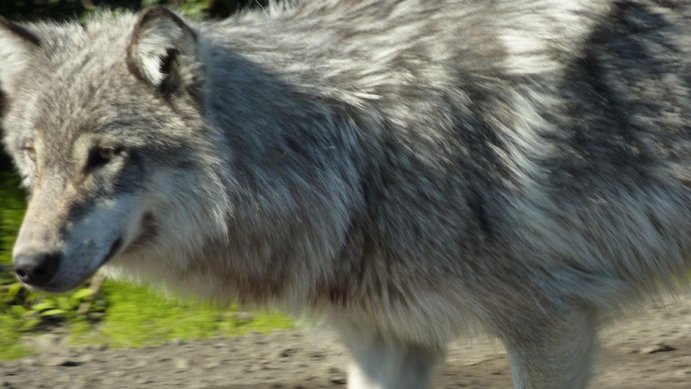
We pause every seventy five miles or so to stretch, drink, and talk about what we've seen. At one point we crested the
top of a hill to find a wolf in the road. Stopping to retrieve my camera from the breast pocket of my riding jacket
(Dave stopped just behind me), we watched as the wolf moved directly toward us, passing by me and sniffing Dave's boot before
moving on. I wasn't sure what to do so I sat motionless until he was gone snapping a few pictures as he passed.
Amazing animal.
The wind picked up as the temprature dropped until riding was more like sailing. The wind would push the KLR hard
from the side and move it across the road on the loose gravel quickly requiring an instant response to keep from joining the
deep undergrowth down the bank on each side of the roadbed. Swamps gave way to creeks and rivers then long expanses
of tundra with large rolling hills and eventually mountains raising in the distance. The smell of honeycomb and cinnamon
was strong at one point. I'm not sure what plant did that but it was welcome. The one constant was the mosquitoes.
At any stop they would be there in droves within seconds of lifting the modular helmet.
We pushed on for 250 miles taking approximatly 6.5 hours to get to the first fuel stop of Eagle Plains. This was
where we first intended to camp. The arctic circle is only 30 miles beyond but the wind had picked up even more making
the desolate oasis- two pump station- grill and bunkhouse (mostly for the truckers that use this road and Helicopter pilots
making a stop) an easy place to dive into and escape the elements. The parking lot was blown smooth by the driving wind
taking much of the dirt with it off of the mountain. The bunkhouse had a room available for the night so we jumped at
the chance to rest for a while and drop off our stuff before heading on the the circle. The time was ten pm but it was
very sunny.
Back on the bikes we pushed on for the remaining thirty miles across a standard steel mesh bridge over the Oglive river
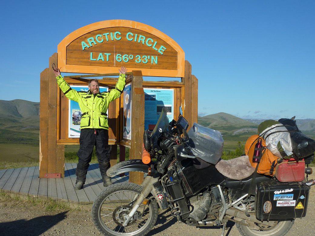
and up to a high mountain pass before decending into the valley where the demarcation point of the arctic circle is marked
with a lonsome but elaborate sign. The sign is visible from the downside of the pass and looks out of place since the
only thing we've seen other than the oasis thirty miles previous was what nature had assembled over the ages. Rolling
up to the pull-off at 10:45 pm we couldn't dismount quickly enough. This was it. The big goal. The stake-in-the-ground
that seemed unattainable just months ago.
Long hours of reading about others journeys, late nights in the garage switching out the bolts that came on the bike
with tempered ones to ensure nothing was left to chance, the right sleeping bag, the right exercises to make sure my back
would survive. This was it.
We posed for pics staring into the sun slowly inching toward the horizon while leaning into the wind. An old station
wagon and camper truck was sitting there when we arrived awaiting the moment of solstice.
A young couple whom we had met earlier on a summit arrived in their new Toyota 4x4 with the brakes squeeling from the
coating of calcium cloride on the road. We talked to Dylan and Tamala about their trip from Vancover Island though
BC and the Yukon and the similarities and differences with our journeys. Again I had the privilage to meet another wonderful
couple enjoying this spectacular land. Happy trails you two!
We were tired. Tired and very very sore. The last thirty miles back to the bunkhouses in Eagle Plains seemed
the longest of the trip. I walked out to the edge of the parking lot to watch the final dip of the sun while Dave showered
the road muck off and engaged in a well deserved teeth brushing.
I snapped a couple of shots with my watch and the sun in the background only to return with the main door locked.
No phone service, no resident stirring, no idea which window on the outside belonged to our room. This was a fine how-do-you-do.
A geologist staying with a group suddenly slammed into the front door on his way out to smoke, unaware it was locked.
"hey, I'm staying here too" , flashed my key, ran in, he ran out.
Good night Emily and Eli, I did it. Thanks for your unending support Cathy. More to come later on the trip
out. It's a hoot.
3:30 am est
June 20- Day 16 Teslin Yukon to Dawson City Yukon
Breakfast will have to wait. Dave and I have a lot of ground to cover today so we'll put a few miles under us then
stop in Whitehorse.
Most of the early travel was just grinding out miles in sparsely populated areas until we hit the capital of the Yukon,
Whitehorse.
Whitehorse has a Wal-Mart albeit not a very big one. Kinda like Roses in Weaverville but they did have the oil
I desprerately needed to continue on to the arctic circle. We grabbed more power bars, snacks, oil, and a McDonalds
meal. Even the McDonalds prices are high. Ten dollars for a double cheesburger, fries, and drink.
More wildlife on the way to Dawson...
Let me share a little about the Yukon. There are 32,000 people in the entire providence with 22,000 of those living
in Whitehorse. About 1600 permanent residences in Dawson, the second largest city, and the rest are scattered around
in small villages across the remainder. This for an area more than twice the size of California. As remote as
BC seemed, the Yukon redefines the term desolate.
The Yukon also has 14 indigenous groups of people, 13 of which have settled with the government for rights to their own
land and self governance. They prefer to be called people of First Nation. First Nation over eskimo or indian
or aboriginal. Charlie David was one of the First Nation residents that told me about the civilizations, or lack of,
around Teslin. Charlie was a slight man with dark black hair thick glasses and a silk shirt. He a habit of
walking off without finishing the conversation only to return a few minutes later and begin where he left off. Charlie
talked about the temprature difference in the last couple of years where the low last winter was only -35 farenheit as opposed
to the -50 or -60 just a few years ago. I told Charlie once it's below 0 it doesn't matter. He walked away again.
Dave and I put in a lot of miles, nearly 500 today and arrived tired and sore to camp at a provencial site across the
river from Dawson. A ferry ride, compliments of the Yukon government, is required to access the sight and road to Alaska.
The mosquitoes are out in force as the rains begin. We hunkered down in my relatively large tent to pour over the
route to the arctic circle and how to get there with the gas we can carry.
Nearly midnight and we force ourselves to sleep.
Night Emily and Eli. I miss you dearly. Wish you were here my love.
June 19 Day 15 Deese Lake to Teslin Yukon
The Yukon....Yeah! Somehow this feels more goal achieving than Alaska.
Dave and I left Dease Lake early enough to catch the mosquitoes sleeping and rode for 250 kilometers before catching
brunch in Watson Lake home of the famous sign post forest. Back in 1942 the Alaska Highway was being constucted by the
Army in some of the most inhospitable terrain in the world under constant battles with moquitoes and terrifying temperatures.
At some point a signpost was erected and pointers indicating the distance to a couple of local outposts were attached.
Some of the soldiers with time on their hands (no internet access) decided to add distances to their homes. The tradition
grew and now 69,752 signs exist. Add one more for the one I attached reading "Jupiter NC 2637 mi" with an arrow pointing
roughly in he direction of our fair community. Of course that's distance in crow flying. My total now is nearly
a doubled 4990 miles.
My old mule is performing wonderfully. A few tweeks as we go including tightening the new chain, another oil change,
adjusting the clutch and lubing the cables made her smile a little.
Today was a long and relatively uneventful day covering nearly 500 kilometers but crossing paths with more of the wildlife.
The original plan was to cover another 220 kilometers but the availability of civilized or bush campsites were suspect
at best.
Tomorrow we intend to complete the ride to Dawson where we will set up a base camp for rides to the arctic circle, back
across a rough high mountain pass to Alaska, pan for gold, fish a little, and day trips around the area. I expect we
will be there about a week.
There are a few things that I can't get over about this land.
First is the amount of daylight. I went to bed last night at 11:30 and it was like 6:00 at home. I have a
pair of the fancy eye patch thingys like the women wear on airplanes in first class that help but the birds don't wear them
so they sing all night. I don't know when it get's dark because it was light again at 4am when nature called me.
Second is the cost of everything in Canada. Regular gasoline is $1.15 per liter or around $4 per gallon US.
A baked lasagna and side salad was $25 and my BLT and drink was $15.
Third is the vast space between civilization here. Most seem to be build around gas stops, most spaced about the
distance between the average automobile distance capability. From central British Columbia, other than
the road beneath my wheels, there are few signs of man's impact on the land or sky. No jet contrails, no power
lines, and certainly no homes. Just the anticipated "wide place in the road" with a few shacks, gas station,
and maybe a small business catering to the road weary traveler. One must wonder what serves as entertainment.
The snowmobiles are probably more necessity in the winter than fun but who knows.
I must shut this thing off and get to bed. 11:30 and the sun just dipped over the horizon. Maybe
the locals will come out to play.
Good night kids, where ever you are. Wish you were here Cathy even though it's not the first place you
would choose. :-)