GEOG 5121 Project 2: Mapping the Census | |
Chesterton, Porter County, Indiana, USA | |
by Tom Wells - May 2003 | |
The U.S. Census Bureau has made an abundance of census data available over the Internet. The following figures present three examples of many possible 2000 Census data maps. Operator-friendly map generation tools facilitate data access and map production for census data visualization.
| |
| |
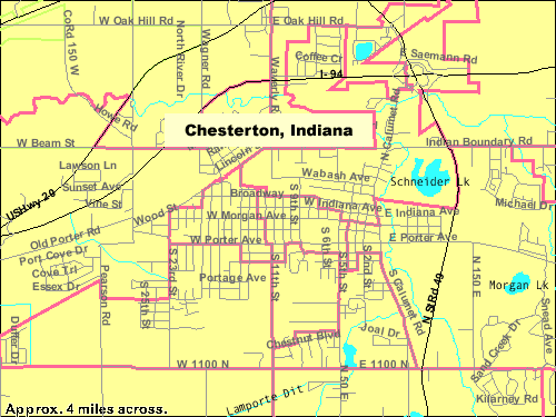
| Figure 1: | The year 2000 Voting District (VTD) boundary map for Chesterton, Indiana as prepared by the U.S. Census Bureau's American FactFinder website (with modified labeling). |
|
Default features are shown on the map including: major roads, streets, streams, lakes & ponds. The map width is 500 pixels, which represents approximately 4 miles. Therefore, 125 pixels equal approximately one statute mile. On a 96-pixel-per-inch screen, the map scale is approximately 0.77 miles per inch (1/49,000). The Census Bureau records geographic locations by latitudinal and longitudinal coordinates. The map projection technique employed by the American FactFinder website is not provided (and map distortion is not noticeable at the scale shown). Note: This map was generated with population density data classes generated at the state level (by default) which are not applicable at the town level of detail shown. Consequently, the data classes are not shown in the map legend. Chesterton, Indiana is a small town near the southern end of Lake Michigan on the edge of greater "Chicagoland", as shown in Project 1. The total population of Chesterton is 10,488 (according to the 2000 Census). The "Chesterton, Indiana" label near the center of Figure 1 purposely covers much of the nearby town of Porter, Indiana, population 4,972. Porter County has a total population of 146,798 (according to the 2000 Census) and is 425 square miles in area (http://www.chesterton.net/).
| |
  |
|
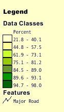
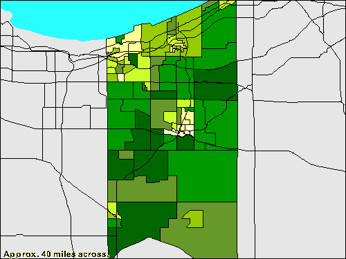
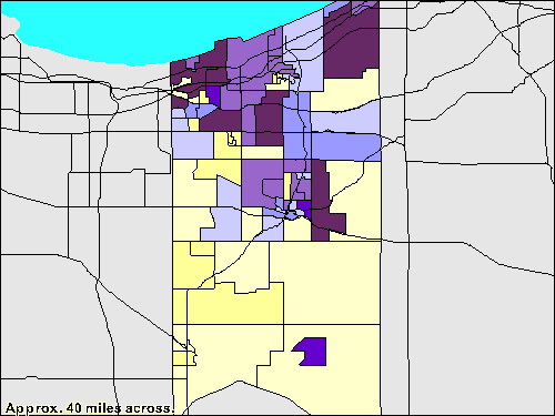
| Figure 2: | A choropleth map of Porter County, Indiana showing the Percent of Occupied Housing Units that are Owner-Occupied, based on the 2000 Census (Summary File 1). |
Major roads are shown because they help identify locations within the county without overwhelming the data classes. The map width is 500 pixels which represents approximately 40 miles. Therefore, 12.5 pixels equals approximately one mile. On a 96-pixel-per-inch screen, the map scale is approximately 7.7 miles per inch (1/490,000). This scale is one tenth the scale of Figure 1. Note: Porter county is 15.1 miles wide.
|
|
| |
| Figure 3: | A choropleth map of Porter County, Indiana showing the Rental Vacancy Rate according to the 2000 Census (Summary File 1). |
This choropleth map is identical to that shown as Figure 2 (and also prepared using the American FactFinder website) except that the data classes represent Rental Vacancy rates. Study of Figures 2 and 3 allows one to see that an area with the highest vacancy rate combined with one of the lowest rates of owner occupation (i.e., a high rental rate) is near the large steel mills in the northwestern corner of the county. | |
Sources | |
| U.S. Bureau of the Census (2003) American FactFinder. http://factfinder.census.gov/ Accessed 11 May 2003 Chesterton Indiana. http://www.chesterton.net/ Accessed 20 May 2003 | |