GEOG 5121 Project 3, Topic F | |
The National Hydrographic Dataset (NHD) | |
by Tom Wells - June 2003 | |
| Technical Detail | The National Hydrograph Dataset
(NHD) refers to a digital spatial data set that describes bodies of water,
both natural and
man-made surface water paths, and related objects
involving the flow of water. The initial NHD combines elements of the U.S.
Environmental Protection Agency (USEPA) Reach files (RF3) and the U.S.
Geological Survey (USGS) digital line graph (DLG) hydrography files. The
NHD is similar to the RF3 and DLG files but is greatly expanded and improved.
Feature names are consistent with the Geographic Names Information System
(GNIS).
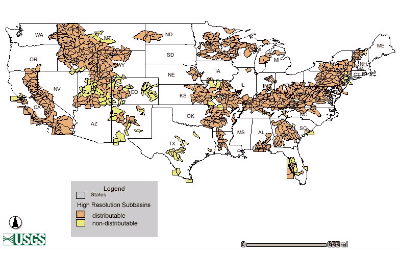
The NHD is a work in progress. Coverage for the entire continental U.S. and Hawaii became available in 1999 based on 1:100,000-scale linework. Higher resolution datasets are being developed to add detail. Current dataset availability may be accessed and downloads for both medium and high resolution datasets may be initiated via a graphical web-based application: "Obtaining NHD Data". (Only the continental U.S. is shown below but the application does include Alaska, Hawaii and Puerto Rico.) |
| Figure 1: |
High Resolution NHD Subbasin coverage in the continental U.S. (June 2003) | |||||||||||||||||||||||||||||||||||||||
|
| ||||||||||||||||||||||||||||||||||||||||
|
The NHD has innumerable scientific and engineering applications. Many professionals such as civil engineers, urban planners, and others may focus on too much or too little water. Others professionals may be more concerned with water quality such as governmental regulators, environmentalists, hydrogeologists, and biologists. The NHD provides a common national framework for the geocoding of surface water-related information and subsequent sharing of data for large area and/or cross discipline uses. In a spatial sense, the NHD can be compared to the U.S. Census Bureau's TIGER (Topologically Integrated Geographic Encoding and Referencing) system with surface watercourses instead of streets. NHD reach codes provide unique "addresses" for georeferencing surface water entities. The NHD also includes tabular centerline routing networks of interconnected surface water drainage features. Surface water features are coded in a consistent manner suitable for digital map production. Applications mentioned in the references include:
|
||||||||||||||||||||||||||||||||||||||||
Technical Details |
||||||||||||||||||||||||||||||||||||||||
|
The NHD is downloadable as ARC/INFO workspaces identified by 8-digit Hydrologic Unit numbers and often called subbasins. Each workspace contains three ARC/INFO coverages plus related information. The NHD coverage contains all of the line and polygon features as network topology. The point features are stored in a separate coverage named NHDPT because the ARC/INFO data model does not allow the mixing of point features with polygon features in the same coverage. The third coverage, NHDDUU, separates the metadata coverage from the feature coverages. The NHDDUU coverage is named after its only theme (spatial component): the Digital Update Unit theme. The main NHD coverage includes the following themes; network element, transport and coastline reach, line landmark, waterbody, waterbody reach, and area landmark themes. The main coverage also includes a node table that can include special "underpass" information to describe intersecting but not hydraulically joined features (such as a canal passing over a river). The NHDPT coverage includes a single point landmark theme. The following table summarizes the three coverages, eight themes and the special nodal feature. |
||||||||||||||||||||||||||||||||||||||||
|
|
||||||||||||||||||||||||||||||||||||||||
|
|
||||||||||||||||||||||||||||||||||||||||
|
||||||||||||||||||||||||||||||||||||||||
|
As a civil engineer who minored in Hydraulics/Hydrology, I
found the USGS's NHD Watershed application most interesting.
I have used
scales and planimeters
to manually measure hydrographic properties from USGS
topographic maps such as hydraulic cross-sections, drainage areas, and flood plain and main
channel reaches. USGS digital data and GIS tools promise to
automate such drudgery.
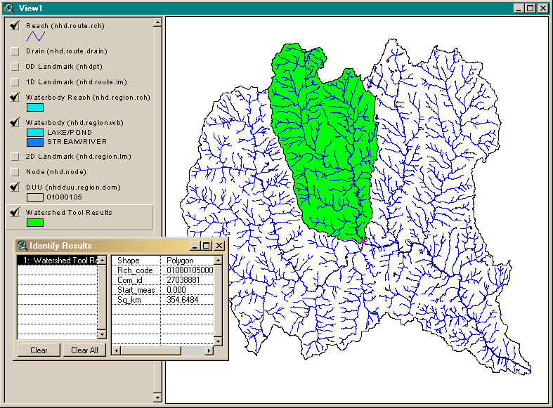
The ESRI ArcView based NHD Watershed application makes it very easy to determine the drainage basin size at any drainage point in a subbasin. Drainage basin size combined with rainfall intensity are the two key factors needed to calculate design flows for infrastructure such as storm sewers and bridges. (Note: an ESRI ARC/INFO based Arc Macro Language tool, Append_NHD, is available from the USGS for combining multiple subbasins into a single NHDinARC workspace.) The NHD Watershed application works with 3 spatial datasets: surface-water hydrography, land-surface elevation, and basin boundaries. Each of these data layers must be modified to work with the watershed tool and each other. Surface-water hydrography centerline data are obtained from NHD networks, and the land-surface elevations are obtained from the National Elevation Dataset (NED). The required water basin boundaries can possibly be obtained from the USDA's Natural Resources Conservation Service (NRCS) and USGS's Watershed Boundary Data-layer (WBD) dataset, or from state agencies, or they can be directly digitized from maps. According to the Instructions for Preprocessing Supporting Data Layers "It is recommended that 1:24,000-scale NHD be used (as opposed to 1:100,000-scale NHD) for the preprocessing steps." The application instructions also suggest that a potential user contact the developer, Peter Steeves, at the U.S. Geological Survey "to determine if this preprocessing has already been performed for your subbasin(s) of interest." A sample NHD Watershed dataset for the State of Vermont's White River subbasin (01080105) is available for download from the application web-page (as is the high-resolution NHD workspace in shapefile format). This dataset was utilized to define the following drainage basin figure. In this case, the watershed was generated from the confluence of the Third Branch of the White River with the main river channel (as indicated by the magenta colored dot at the downstream end of reach number 528). Note: The ESRI ArcView Spatial Analyst extension is required to delineate watersheds from any point on any NHD reach. Without the extra cost Spatial Analyst extension, watershed delineation can only be performed upstream from an NHD reach node. The Watershed application was developed with the free USGS NHD ArcView Toolkit. This ArcView 3.x extension toolkit makes it very easy to load a NHD workspace into ArcView. There is also an included Navigation tool that can use the NHD reach flow relationships to automatically select reaches upstream or downstream from a user-selected reach. Other tools include "Reach Indexing" for associating related data, and conversion tools for "NHDinARC to NHDinSHP" shapefile conversion, and "INFO to DBF" file conversion. |
||||||||||||||||||||||||||||||||||||||||
|
||||||||||||||||||||||||||||||||||||||||
| Figure 2: | Watershed delineated within Vermont's White River subbasin using the USGS's NHD Watershed application with ESRI's ArcView 3.2. The highlighted watershed has an area of 354.6484 square kilometers. | |||||||||||||||||||||||||||||||||||||||
|
||||||||||||||||||||||||||||||||||||||||
|
High Resolution subbasin data is not available for our
area in Northwest Indiana. (However, an adjacent subbasin (07120003) to the northwest in Chicagoland,
does have high resolution data available. See Figure
1 above.) "Medium" resolution coverage based on 1:100,000-scale
linework is available for the entire continental U.S.. Chesterton,
Indiana is crossed by Coffee Creek near its confluence with the Little
Calumet River. The Little Calumet River is one of multiple rivers that
flow into nearby Lake Michigan in
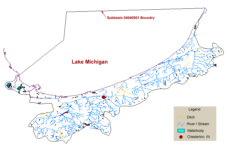
subbasin 04040001.
The following figure was created with ESRI ArcView 3.2 and Adobe Photoshop 6.0 using the NHD 04040001 medium resolution subbasin data set. The southern boundary of this subbasin is a major surface water divide since the adjacent Kankakee River valley drains into the Mississippi River via the Illinois River. Lake Michigan is one of the Great Lakes which flow into the St. Lawrence Seaway. The NHD 04040001 subbasin dataset does not contain any point (0-D) landmarks or 2-D landmarks. It does contain two 1-D landmarks (both are "non-earthen" shoreline, representing sheet piling near a steel mill). All NHD nodes indicate hydraulic connectivity. It is interesting to note that the streams near the bottom of Figure 3 extend beyond the subbasin boundary. This area includes a variety of hydrological features from well-drained glacial moraine uplands to poorly drained interdunal marshes. Surface elevations vary from Lake Michigan (which is currently near its historic low -- approximately 577 feet above mean sea level), to roughly 860 feet at the top of the Valparaiso Moraine. One sand dune, Mt. Holden in the nearby Indiana Dunes State Park, rises to 763 feet, which is approximately 186 feet above nearby Lake Michigan. |
||||||||||||||||||||||||||||||||||||||||
|
|
||||||||||||||||||||||||||||||||||||||||
|
Figure 3: |
NHD Subbasin 04040001 |
|||||||||||||||||||||||||||||||||||||||
|
Note: The 04040001 subbasin covers approximately 64 miles in latitude and portions of three states: Illinois, Indiana and Michigan. Two and one-half counties in northwest Indiana include Lake Michigan coast line. (The top of all three figures face North.) | ||||||||||||||||||||||||||||||||||||||||
Sources | ||||||||||||||||||||||||||||||||||||||||
Warning:: The USEPA's website has very out-of-date answers to the following questions found (6/4/2003): at:
This out-of-date information found on the USEPA's website suggests that the USGS is a better source of information. (http://nhd.usgs.gov/ is a USGS website and a great NHD reference URL)
|
||||||||||||||||||||||||||||||||||||||||
|
Appendix - USGS NHD ArcView Tutorials | ||||||||||||||||||||||||||||||||||||||||
|
Six ArcView 3.x Tutorials are available online at the UGS website (http://nhd.usgs.gov/tutorials.html). The tutorials are well worth the time and effort as a NHD and ArcView learning tool. (There is also a single ArcExplorer tutorial at the same URL.) If you would like to download my ArcView Projects (rather than create your own from scratch), they are available online. Each of the six tutorials uses a different NHD subbasin, which must be downloaded and unpacked separately. Hence there are six separate ArcView projects. The Views are named after the tutorial steps that they present when opened in ArcView. There is at least one view in each project. (Right-click on the Tutorial file link of interest below and select "Save Target As..." (or the equivalent) in your browser. Make sure the ArcView-formated file is saved with an ".apr" suffix.)
| ||||||||||||||||||||||||||||||||||||||||


