GEOG 5222 Project 3 | |
Locating Tornado Relief Sites | |
by Tom Wells - July 2003 | |
| Candidate Sites Map |
This project uses some of the same tornado event data from the May 3, 1999 super-cell
storms in central Oklahoma that was used in Project 2. That project
summarized and presented the data using ArcView 8.3. This project combines a
public facility layer with fundamental ArcView GIS based geospatial
analyses to
select potential relief center sites near the most damaged areas.
Project 3 was described in four parts.
Buffer & Overlay operations plus the Thematic Legend Entry are introduced in this lesson / project.. |
|
| |
|
| |
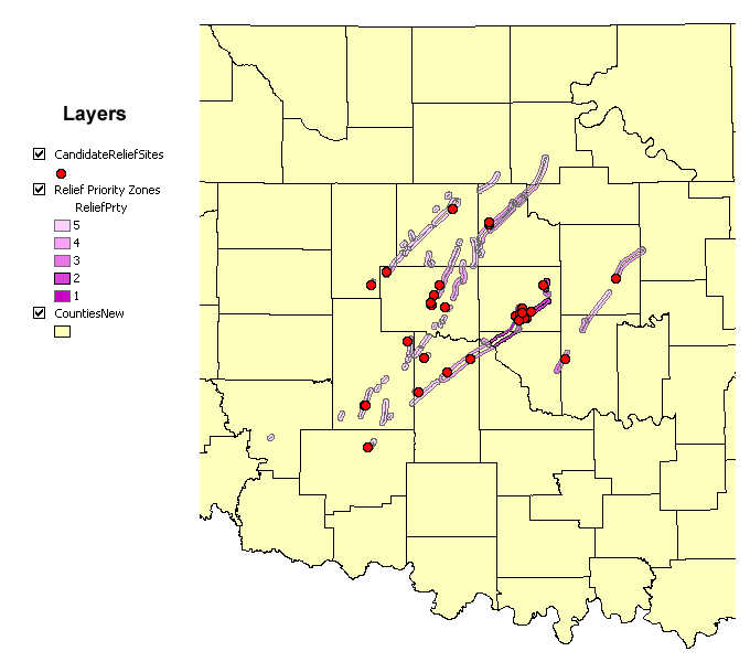
| Figure 1: | May 3rd, 1999 Tornado Path Relief Priority Zones and Candidate Relief center Sites in central Oklahoma State. The map represents approximately 200 miles horizontally. |
|
|
| Figure 2: | Candidate Relief center Sites in central Oklahoma state located within one mile of Buffered May 3rd, 1999 Tornado Paths |
|
"Only" one May 3rd, 1999 Tornado was rated F-5, the most destructive rating, on the Fujita scale. Figure 3 below shows the entire F-5 Tornado path including portions in Oklahoma County. The buffered width of the F-5 Tornado path is 1,760 meters (which is wider than a mile, I.E. > 1,609 meters). This F-5 tornado path is 38 miles long! The Figure 3 map clearly shows how the Relief Priority Zone ratings change based on the county location due to changes in county population density. (See the Appendix.) This sub-zone rating / coloring was a product of a Spatial Intersection (as described in Lesson 3, Part 3.D). An interesting complication is this case is overlapping zones. Sometimes the lower priority color is mapped instead of always showing the more critical higher priority color on the map. In particular, consider the small tornado path overlapping the border of south central Oklahoma County. |
|
|
|
|
|
Figure 3: |
May 3rd, 1999 Tornado Path Relief Priority Zones and Candidate Relief center Sites in central Oklahoma State including all of Oklahoma County. Relief Priority Zones were calculated from the supplied county population data (male plus female). The map represents approximately 50 miles horizontally. |
|
|
|
|
Optional Additional data from the federal US 2000 census was downloaded (from psu.edu) for Lesson / Project 2 and utilized to create a more detailed Housing Density map based on census track data instead of state county data (see Figure 5.) This same data set was used here to produce a more detailed set of Relief Priority Zones based on US 2000 census track data instead of the more general supplied county population data. Figure 4 below also shows the census track boundaries. |
|
|
|
|
|
Figure 4: |
May 3rd, 1999 Tornado Path Relief Priority Zones and Candidate Relief center Sites in central Oklahoma State including all of Oklahoma County. Relief Priority Zones were calculated from US 2000 census track data. The map represents approximately 50 miles horizontally. Census track boundaries are shown within the counties. |
|
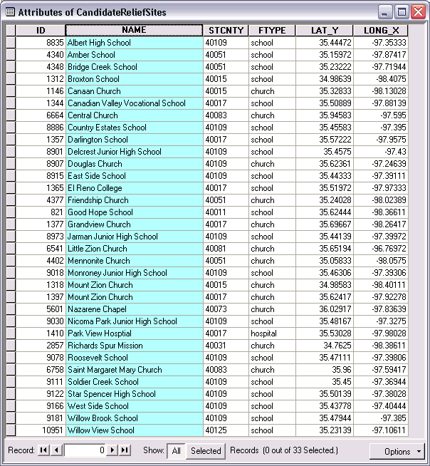
Candidate Relief Sites have been selected on a relatively simplistic basis. Only schools, hospitals, and churches have been considered and they only need to be within one mile of a tornado path for consideration. The Candidate Relief Sites have not been classified on the basis of their proximity to the higher priority zones and/or the center of the tornado path. (I.E. a facility near the end of tornado path is probably not as valuable as one near the middle if all else is roughly equal. However, facilities are more common in the more populated areas so they would tend to be near the area of greatest need.) The Relief Priority Zones are classified on an inferred need based on the strength of the Tornado versus the population density. The actual county-wide housing unit damage and destruction was mapped in Project 2. Actual damage data could be more accurate than inferred damage (because tornados are not consistent and structures vary). However, I imagine that Tornado Paths can be determined quickly from radar images in near real-time whereas actual property damage information must be laboriously gathered after the event has occurred. |
|
|
Sources | |
|
|
|
Appendix | |
|
In Part 3.E of the Lesson, an added field is populated based on the following equation using two other fields (in the same attribute table).
Where:
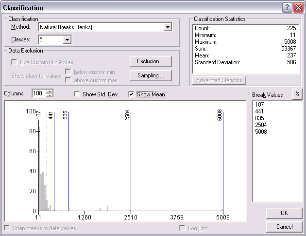
The graduated colors were assigned based on the default classification method shown below. There is "only" one F5 tornado and it did enter the most populated county so there are only two Relief Priority Zones with a ReliefPrty (relief priority) in the highest classification. (Two zones because of a tornado path overlap.) The "Natural Breaks (Jenks)" classification method worked well. "Thematic Legend Entry" was used to change the default classification legend labels to 1 thru 5 where number 1 is the Highest Priority. Note: The example in Lesson 3, Figure 10 displays the reliefprty (relief priority) classifications in the reverse order from mine. Starting with 1 at the top instead of 5 may help the viewer realize that 1 is the Highest Priority. In either case, we both use the darkest color for the highest priority. I believe that I used the default classification order based on the lowest (top) to highest (bottom) Break Values. The order can be reversed via pop-up menus accessed on the Layer Property form's Symbology tab column headers. |
|
|
|
|
|
Figure 5: |
Classification used to produce Figure 3. |
|
Go To the Top of Page | |