GEOG 5222 Project 5 / 6 | |
Designing a Thematic Zoning Map Presentation | |
by Tom Wells - August 2003 | |
| Zoning Map |
ArcView 8.3 can produce traditional looking paper maps with ArcMap's
impressive built-in desktop map publishing capabilities.
This project showed us how to use the "Layout View" to combine
essentially two maps on a single page. Project 5 / 6 was described in two
lessons.
Lesson 5 contains four parts:
The major new operation in this lesson was the generation of road name labels. ArcMap can do most of the work but it can not resolve label overlap situations without interactive operator intervention. By converting the the generated labels to graphical annotations, they can be "manually" repositioned. Some of the generated labels without automatically detected overlap situations were repositioned for improved readability as well. Lesson 6 contains three parts:
Most of this lesson involved using ArcMap in new ways because this was our first required usages of "Layout View" instead of "Data View". Unlike Data View mode, Layout View lets the operator work with multiple data sets / maps on a page. Layout View also lets one insert a title, neatlines, scalebars, scaletext, and legends. |
|
In the following figure, two maps in separate "data frames" are shown; the relatively large main Zoning map and the relatively small Inset map. ArcMap also generated the scalebar and the directional symbol. The Key / Legend was mostly computer generated then manually improved after converting it to graphical annotations. The "WTS" logo was drawn in PhotoShop. | |
|
| |
| Figure 1: | White Deer Township Zoning map, Union County Pennsylvania. Both maps are displayed using the Pennsylvania State Plane North, NAD 1983 projection. A high resolution Adobe Acrobat (pdf) file is available for download and printing on "A" size paper (8.5" by 11"). The map is very readable when printed full size (instead of 640 by 482 pixels as shown here). |
|
The optional data set was downloaded and used to produce the small inset map shown within Figure 1. One set of shape files (counties.*) contains a polygon for each of the 67 counties in the State of Pennsylvania. Union County was selected and exported as an additional layer to make it easy to color fill differently than the other counties. Likewise, the other set of shape files (municipalities.*) contains information for each township in Union County. White Deer Township was selected and exported to create its own layer for identification purposes. (This approach was easier than customizing the legend.) | |
|
The flood plain is quiet large because White Deer Township is bordered on the east by the Susquehanna River. The Susquehanna River is the nation's sixteenth largest river. It is also the largest river lying entirely in the United States that flows into the Atlantic Ocean. The drainage basin is 27,510 square miles in size and the river is 444 miles long from its source at Otsego Lake in New York state to Chesapeake Bay. The township map was produced in a data frame with a map scale of 1:7,500,000. The inset data frame scale is exactly 100 times larger: 1:75,000. I was pleased to find that ArcMap can generate / export PDF files without the purchase of Adobe Acrobat. The pdf file is not just an image of the map in that the map's text can be searched (via ctrl-f) and copied into the Windows clipboard. | |
|
Sources | |
|
|
|
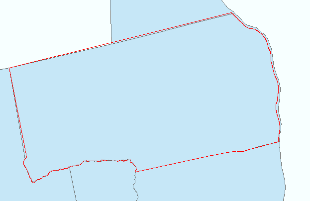
Appendix The following figure was generated while determining the coordinate system of the optional downloaded data set. Fortunately the list of possibilities was limited to the following list because there are hundreds of projections available in the system. A search for ".prj" projection files in \ArcGIS\arcexe83\Coordinate Systems found 2,053 files ! (Apparently one for each supported projection.)
The red line representing the White Deer Township political boundary comes from the "wdboundary arc" shape file in the CD-R supplied data set with the known coordinate system of "NAD 1983 StatePlane Pennsylvania North FIPS 3701 Feet". The best match (by far) with the downloaded data was made as shown below with the "North America Albers Equal Area Conic" projection specified for the Municipalities shape files. Figure 2 just shows a small portion of the downloaded data set to maximize the visible difference. The township appears to be rotated because "we" are not use to viewing such a projection of the State of Pennsylvania. | |
| Figure 2: | The outline of White Deer Township, Union County Pennsylvania using two different data sets. The projection is "North America Albers Equal Area Conic" instead of the " Pennsylvania State Plane North, NAD 1983 projection" used in Figure 1. |
|
The optional data set demonstrates how ArcView can easily translate from one projection to another. Naturally, ArcView does need to be told the correct coordinate system used by each data set / layer. | |

Go To the Top of Page