Portland
Vintage Trolleys

|
|
|
|

| This library of
historic streetcar maps of Portland will
be added to as further maps are
discovered, scanned, drawn or otherwise
made presentable on the Web. |
|
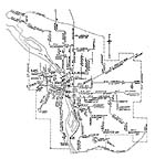
This 1904 map
is based upon an original printed in the Street
Railway Journal
(Dec. 31, 1904 p. 1135). It shows the
Portland system a year before
the amalgamation process that would become
the Portland Railway, Light
& Power Co. There were two chief
traction rivals in 1904, the
City & Suburban Railway Co. with 67
miles of track, and the Portland
Railway Company with 41 miles. |
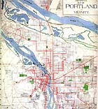 |
American Map and
Reproducing's Map of
Portland and Vicinity was
published in 1912
as
the street railway system approached its
peak. Most of the country's
3rd largest narrow gauge system was in place
soon thereafter as stub lines
were built to new developments in Errol
Heights, Murrayhead and Westover
and extensions added to the Hawthorne and
Mt. Tabor Lines. |
 |
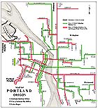
Although this map appeared in the 1924edition
of Pittmon's Portland Offical
Guide the same drawing
appeared from 1920-27
without updating.
Line changes continued to be made during the
Portland Electric Power Co.
(PEPCO) years, but they may have been too
subtle to have inspired a redrawing
for the pocket guide. New routes were
added, such as Municipal Terminal
(1922) and the Greeley cutoff for St. Johns
(1926), and existing lines
were cut back or merged with other
lines. For example, Depot &
Morrison became Willamette Heights and gave
its downtown terminus to the
Council Crest Line, and part of the 16th St.
Line was joined with Williams
Avenue.` |
 |
When the 1st National Bank Guide
Map appeared in 1933
the Great Depression was well under way and
the Portland Traction Company's
streetcar system was in decline. A
large number of lines were converted
to trolley or gas bus, or simply abandoned,
during 1936-37, including Beaumont,
Hawthorne, Fulton, Irvington, Mt. Scott,
Murraymead, Richmond, Rose City,
Russell-Shaver, St. Johns, and Westover, and
Woodlawn. |

|
|