|

|
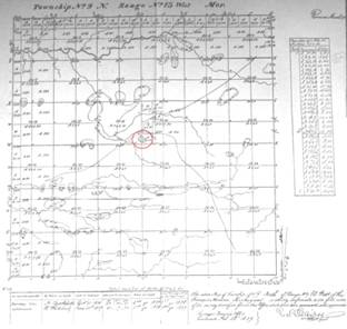
| 1837 Survey Map of Chester Township - Indian Settlement Shown Inside of Red Circle |
The first surveyor, N. Brookfeld, began his work in what would become Chester Township
in 1837. Brookfeld completed his portion of the survey in 1838. He was followed by R. Whitcomb, who completed the survey in 1839.
With the completion of the survey, the land then was put on the market in late 1839.
Native American Residents
Little is recorded about the Native American population in the area. However, in the survey notes, it states that there was an Indian settlement of about 300 people living
in the area of Crockery
Lake.
White Settlement
White settlement actually began in late 1845 when several
families purchased land in the township. Among those who bought land during that
year, in order of date of purchase, were: Zerial Waterman, John Pintler, Phillip Fahling, Conrad Kritzer, Adam
Lachmann, John S. McClain, Sylvestor B. Taft, Reuben Woodman, Joel French, Edward Gardner, and George Irish.
In 1846, several more families purchased land in the township. Among them were William Bradbury, Aaron
Batson, Oliver H. Merrick, and James Rowlinson. Not all of the new land owners
built homes immediately. Some waited a year or more before building a house and
moving their families to the township. It is known that John Pintler and Phillip
Fahling built homes and lived in the township by the spring of 1846. In fact,
Phillip Fahling’s daughter, Margaret E., was the first white child born in the township on April 24, 1846.
The area comprising Chester
Township was part of Tallmadge Township
from 1838 to 1847. Then from 1847 to 1848, it was included with Wright
Township. The bill establishing Chester
as a separate township was dated March 11, 1848. The portion of the bill pertaining to Chester Township
is found in Section 5, Act 60, Public Acts of 1848. It reads as follows: “That town number nine north, range number thirteen west, in the County of Ottawa,
be, and the same is hereby set off from the township of Wright, and organized into a separate township by the name of Chester,
and the first township meeting therein, shall be held at the house of John S. McLain*, in said township.”
It is said that the township was named “Chester”
after one of John McClain’s son’s who had been born in Lenawee County shortly before the family moved here. Although John had purchased land here in 1845, the family did not move here until
1846.
The first town meeting was held in 1848, with nine voters
attending. John McClain* was elected the first Supervisor of Chester Township. O. H. Merrick was the township clerk and Justice of the Peace. George Irish was the Assessor. Just two years later, in 1850,
at the state election, fifty-three votes were cast in the gubernatorial race.
As the population in Michigan
pushed northward, Chester Township was
expanded in 1850 to include what is now Casnovia Township. In 1852, Casnovia Township
was separated from Chester and became an independent township.
John McClain served as Supervisor for several years. Among the Supervisors prior to 1880 were W. H. Harrison and George F. Porter. Mr. Porter was elected State Senator in 1890 on the Democratic ticket.
In 1881 Chester
Township’s assessed valuation equaled $424,864. The township’s entire share of the Ottawa County
tax totaled $1,298.17; Michigan State
tax totaled $807.24; the Chester Township
tax amounted to $300.00; and the highway tax equaled $311.00.
The early, rapid growth of Chester Township is revealed in the
census figures. The population of the township was listed as follows: 1850 census – 216; 1854 census – 500; 1860 census – 721; 1864 census – 1034; 1870
census - 1,405; 1874 census – 1,397; and 1880 census – 1703.**
*Spelled variously: McLane, McLain and McClain
**Historical and Business
Compendium of Ottawa County,
Michigan,
1892-3, Grand Haven, MI: Potts & Conger, 1892.
History
of Ottawa County, Michigan, with illustrations and biographical sketches of some of its prominent
men and pioneers, Chicago : H.R. Page & Co., 1882.
|

