The first “roads”
in Chester Township were merely trails blazed
by the Native People living on the south side of Crockery Lake. The 1839 survey map of Chester Township indicates three main trails. One trail led northeast from the settlement.
Another trail advanced in a southwesterly direction. The third trail proceeded
southeast from the settlement at Crockery Lake to another settlement at Cranberry Lake in Wright Township.
Click
on the following link for the 1839 survey map showing the Native People settlement and trails.
After the arrival of the first white settlers, township roads remained
simple trails that allowed settlers, either walking or on horse back, to move from one settlement to another or from outlying
farms to the nearest settlement. These early pioneers had to widen the trails
to allow wagons to move easily to take goods to and from larger settlements. Then
stage lines contracted for the building of dirt roads. One line running from
Grand Rapids to Newaygo passed through Lisbon.
Another from Muskegon to Grand Rapids passed through Six Corners.
For over half a century,
the Chester Township
Board was responsible for the improvement and repair of all roads in the township. The
township electors voted for a Highway Commissioner each year, then in later years, the terms of office were increased to two years. The office of Chester Township Highway Commissioner was abolished
in 1963. As the duties of the Highway Commissioner became too much for one person,
the electors also voted for Overseers of Highways. At first two Overseers were
elected, then in 1911, the township was divided into four road districts and four Overseers were elected.
For a list of the Highway Commissions who held office between 1887 and 1963, click on the following link.
The building, improvement
and maintenance of local Township roads were a major undertaking during the early years of the township. The roads had to be surveyed. Often trees, large stones, swamps,
streams and other obstacles had to be overcome. The Township Highway Commissioner
and his crews had to clear the right of way and grade it. They built bridges
and hauled and spread gravel using only teams of horses or oxen.
Payment for road work was
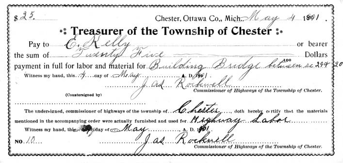
low. The 1901 payment voucher, below, is made out for $25.00. This payment was for both labor and materials to
build a bridge across the Rio Grande Creek between sections 29 and 30. The "3" in 30 looks more like a "2" on the voucher.

|
| 1901 payment voucher for building a bridge. |
At the April 3, 1911 Annual Township Meeting, there was a proposal on the ballot,
“Shall the County Road System be adopted by the County of Ottawa?” The vote on this proposal in Chester Township was 12 yes and 252 no. However, in the county, as a whole, the measure passed and the Ottawa County Road Commission was born. “The day was May 4, 1911. At County
Clerk Jacob Glerum’s office in Grand Haven the newly delegated officials known as the Board of County Road Commissioners
held their first session.” (Sixty-Five Years, A History of The Ottawa County Road Commission, 1911-1976, by Lynne Deur,
A Bicentennial Project of the Ottawa County Road Commission)
Based on the decision of
the Ottawa County
Board of Supervisors, rather than the Board of County Road Commissioners, a total of 206 miles of roads in the county were
approved to be built, with 18.5 miles of this total in Chester Township. Even though the new Road Commission was soon to begin
constructing and maintaining roads in the township, the Chester Township Board, with the approval of the electors of the township, continued to undertake their own road improvement
and repair program.
It wasn’t
until July 28, 1931, that the Township Board voted to turn over 12 miles of local township roads to the Ottawa County Road Commission.
Then on February 16, 1934 the Board voted to turn over another 13.5 miles of local roads to the County.

|
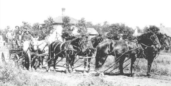
| Road crew using a horse & mule drawn grader to grade Conklin Street. |
The citizens of Chester Township have a long history of supporting the construction and maintenance of local roads. As early as the first Township Board was elected, citizens approved the raising of monies for roads through
property taxes. Usually the motion was not for a specific millage rate, but rather
for a set amount of money to be raised. At the Annual Township Meeting held on
April 4, 1887, the following motion is recorded in the minutes, “It was moved and carried that the sum of Six Hundred dollars
be raised this year for General Highway Purposes.” At other times, the
proposals were closer to what we recognize today, such as, on October 4, 1906, when the Township Board voted to “raise 3/5 of
1% on the assessed valuation for highway purposes.” Then at the April 3, 1911,
Chester Township
Annual meeting, the electors approved 2.5 mills for road repairs and 3.5 mills for road improvement. There is no mention in the minutes of how many years this road millage was to last, but it can be assumed
that it was intended to last for one year only. Chester Township also took advantage of whatever
state aid was available for the construction and improvement of roads.
The minutes of the Ottawa County Road Commission record that on
August 9, 1945, the Road Commission was presented with a
proposal from William A. Schaeffer and Avery Ebers to blacktop the mile of road on the east side of Section 36 (Kenowa) between
Wilson and Harding. The Board agreed to perform the work and “build up
the road” prior to blacktopping. Upon completion both gentlemen agreed
to pay $400 each for the project. Then at their May 29, 1946
Road Commission meeting, Engineer Bowen reported having attended a meeting of the Farmers Union of Chester Township. He discussed “road financing” and
reported on the progress of the “1946 program of road grading.”
It
wasn’t until 1946 that the section-line roads in Ottawa
County, including Chester
Township, were named. Of course,
a few of the roads in the township had already been given names. Gooding was
named after the village of Gooding. Conklin Street was named after the Conklin family; Daggett Street after the Daggett family; Miller Street after the Miller family; and Sehler after the Sehler family. Two of the
streets in Conklin were given tree names – Maple Street and Cherry Street. There was a Grove family in Chester Township, but it is unknown if Grove Street was named after this family or if it signified a “grove” of trees.
Prior
to the official naming of the roads, roads were often referred to by their location, such as, the road between Section 24
and Section 25 or to build an iron bridge across the Crockery Creek between Sections
Three and Four. This makes it easy to identify, today, where the work was being
done. However, some of the descriptions make it harder to identify the exact
location of the work, such as, taxation to build two iron bridges across Crockery Creek on or near Harrison T. Barrett’s
and another near Levi Miller’s.
It was in 1970 that an ambitious
road paving program was begun by the Chester Township Board. The Board asked the voters to approve millage
for roads construction (paving). Initially, in the August Primary, the millage
was defeated, but it was put before the people again in the November general election and passed. The Township began paving one or more miles of road each year. The
decision on the order in which the roads were paved was based on traffic counts, the number of people who lived on the road
and the condition of the road itself. The voters of Chester Township continued to approve millage
for the paving of roads each time a proposal was brought before them. The last
mile of paving was completed in 2003.
Sixty-Five Years, A History of The Ottawa County Road Commission, 1911-1976, by Lynne Deur, A Bicentennial Project of the Ottawa County Road Commission
Chester Township Board Minutes, 1887-2003.
|

