|
|
Tom Wells
Certificate Program in GIS |
|
| GEOG 5121 | GIS technology is becoming commonplace as hardware & software costs continue to drop. As a Civil Engineer specializing in Geoenvironmental Data Management, I need to understand how GIS technology can help turn raw data into useful information. I have considerable experience with site-specific data management and I have learned additional "big picture" data management and analysis skills through these four online courses. |
|
Geography 5121 Projects Project 1: Coordinates and Map Projections This personal application of mapping technology helps one relate to coordinate and mapping projection study materials. Click the above link to see where we live near a Great Lake.
Project 2: Mapping the
Census
Project 3: Acquiring
Geographic Data - The National Hydrography Dataset
|
|
|
Geography 5222 Projects Project 1: Decision Support with GIS Where should the ice cream store go ? An introduction to spatial and attribute based site selection with ArcView 8.3. Project 2: Manipulating and Summarizing Attribute Data Tornado property damage in central Oklahoma on May 3rd, 1999 is presented using ArcView 8.3 to produce thematic maps with an overlay of actual tornado touch-down paths. Project 3: Analyzing Spatial Data in a GIS How can a GIS system help target relief efforts after a major series of
storms with Tornado damage ? Project 2 data is combined with a public
facilities layer to select possible relief sites near the areas with the most
likely need.
Spatial data can often only be located based on a street address. So how can an address be converted to a geographic location ? Project 4 provides a home address geocoding exercise combined with a simplified radon gas risk analysis. Project 5 / 6: Designing a Thematic Map Presentation This project produced our first traditional looking map designed for printing and standalone usage. ArcView 8.3 is very capable of producing printable maps suitable for most purposes as demonstrated by the "White Deer Township Zoning" map. Project 7: Introduction to Raster GIS Analysis Where is the acreage most suited for vineyards in (a small portion) of Napa County, California ? Project / Lesson 7 considers seven different criteria to identify the most desirable vineyard acreage. The ArcGIS Spatial Analyst extension is put to work in this project. Final Class Project: A Significant GIS Analysis We have identified Priority Conservation Areas in Centre County, Pennsylvania without a "guide book". Each student had to submit a Work Flow to the instructor for approval based on the supplied data and project instructions. This is a relatively complex analysis so multiple approaches are possible and each student was free to choose their own path.
|
|
|
Geography 5223 Projects Lesson 1, "Data Input" and Lesson 2, "Data Correction &
Integration" do not have published projects here. Instead, the
personal geodatabase was e-mailed to the grader twice. Lesson 1 gave us some
hands-on "Heads-Up" digitizing experience. Lesson 2 had us find
and correct mistakes in an adjacent area to the Lesson 1 study area then merge the two
sets of GIS layers together.
Project 4: Database Design
Project 5: Data Acquisition via the World Wide Web A data set of Census Block Group information was downloaded from a clearing house and prepared for usage in Project 6. Project 6: Spatial Dataset Creation and Visualization This Lesson leads the student through the creation of a spatial data set that is joined with 2000 Census data from Project 5. Some of the data is then presented using thematic mapping. Final Class Project: Reconstructing 1920 Charlottesville, Virginia The Final Class Project simulates a realistic proposal / pilot project effort. Historical maps were digitized and assembled in a GIS for a Historical Society client. We formed a group of student volunteers to complete the ambitious project; the SketchTools (as we were dubbed by the instructor). Other members of the group include: David Beahm, Tom Bell & John Branigan
|
|
|
Geography 5224p Projects This is one of three final course options in the Certificate Program in GIS.
I choose the GIS Programming and Customization course because of my unusual
computer oriented Civil Engineering career. (The
5224e: GIS
in Practice: Environmental Applications course looks very interesting too.
Perhaps I will enroll in 5224e next winter even though 'only' 4 courses are required
for the GIS Certificate.) The first programming project includes some simple ArcView user interface customization and a classic "Hello World" exercise in the ArcMap 8.3 VBA (Visual Basic for Applications) event-driven environment. Lesson 2 & 3: Intro to Programming ArcObjects Lesson 4/5: Working with Maps and Layers Lesson 6/7: Working with Tables and Performing Queries Lesson 8/9/10: Final Project (Designing a 911 Update Application) Only Lesson 1 has a personal posted project. The Final Project was a group effort and the user manual was posted online. The in-between lesson projects and the final project included sending the instructor either an ArcMap document or a template file.
|
|
|
|
|
|
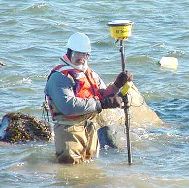
GPS Surveying in the Tidal Zone
Trimble Total Station 4800 GPS instrument shown with Tom Wells on site in Long Island Sound. Click on the picture to see the Trimble Total Station 4700 GPS base station used to correct the "rover" instrument. |
|
|
Go To the Top of Page / Home |